Thursday, 13 April 2017

Dales Way 2 Monday 20th March

Dales Way 2
20th March 2017
Cicerone Guide, The Dales Way (2005); map OL297
Ilkley to Bardon Bridge – 9.3 miles

The day dawned grey and damp – not really raining, but certainly not dry either, with dark clouds threatening to rain. Sandra assured me that the forecast was dull and damp today, but it was going to clear up as the week progressed. Despite not getting to sleep very early, I woke up at 6.30am and after about half an hour, I got up, had breakfast and found that Sandra was up early as well, so we decided to set off as soon as we had finished breakfast.

The first thing we needed to do was to drive to Barden Bridge so we could drop off one of the vehicles, then drive back to Ilkley to start the walk. Sandra arrived at Barden Bridge first and had walked up from the car park to meet me on the higher road. She advised me that the lane was awkard and narrow to the car park as was the bridge (the car park being on the far side) and so suggested I turned round where I was. Easier said than done! Eventually, after a lot of to-ing and fro-ing (a nine point turn??) I managed to find myself facing the opposite direction, and with Sandra on board, I drove back to Ilkley and parked in the spot we had decided on last night.


The path was variable – some of it was at least semi-paved; other parts were just dirt paths and mostly single file and narrow. There had been a substantial amount of rain during the preceding days, so the ground was very wet and muddy – even on the paved parts there were massive puddles right across our way. On the dirt paths, it was like walking through treacle – very ‘gloopy’, with serious danger of slipping over – either into the mud, or into the river which ran alongside and had huge amounts of water in it! 


[Apologies for the darkness of the pictures - I changed the settings on the camera later and they are not so dark. I know it was raining, but it really wasn't quite as dark and gloomy as the photos make out!]

Having Storm along didn’t really help, as she was excited to be walking and so was pulling like a steam train to get ahead. Sandra was out in front and Storm thinks that is her place – she needs to make sure the path is quite safe for her whole ‘herd’ before we are allowed to walk on it! Eventually, we sorted out who would be out front (Storm, of course) and we came along behind her. Because we had the extendible lead, it didn’t make much difference which of us was in front of the other, just as long as Storm was in front. Note to self – work on making Storm walk to heel more!

I was very glad I had worn my waterproofs, as the mud really splashed up everywhere. By the time we had got to Addingham, I was covered in mud up to my knees, even though I had not fallen over, despite Storm’s best efforts. Of course, Storm, being a dog, can’t wear waterproof trousers, so she was covered too half way up her sides and all of her underneaths.

Addingham was a delightful little village. Was walked along a lovely narrow and traffic free lane for a while after coming off the path next to the river. There were some lovely houses along the lane – but one (turned out to be the former Vicarage) was exceptionally beautiful. A stream ran through the garden and they had made every effort to make a feature of it – and very successfully too. It was stunning!

Just past the old Vicarage, we turned right and headed towards the old church. 


We decided to visit it as it has a blue clock face (a rarity, we understood) 


and is a ‘Thompson’ church, by which I mean, Thompson the ‘mouse man’. He made furniture and wood panelling for houses and churches, his trademark being a little carved mouse. I have even seen a carved wooden sheaf of corn (the kind used to decorate a church on harvest Sunday) with a little mouse carved into it – but that was elsewhere, not here. We went inside separately – we didn’t think a very muddy dog would really be welcome inside, though two pretty muddy people might have been rather unwelcome too, though no-one said anything. The church was full of workmen and women. After looking around a while, I had to ask about the mice. Apparently there are 15 in total and they often have school trip visits and set the children the task of finding all the mice. There is one however that no-one ever finds – it is carved into the wooden cross hanging over the bit where the nave meets the chancel and has the back end of a mouse on one side and a hole on the other, with the head of the mouse inside the hole. The cross was too high and I couldn’t see it, but I did see several others – once they had been pointed out, that is.


The mud bath continued past a weir or two 


and we spotted a Mandarin duck and his wife swimming downstream. I say ‘swimming’ but really the current was so fast, he was simply being carried along by the stream. 


There was also an abundance of lambs in the fields, so Storm needed to be kept on a pretty short lead – which was exhausting, as she really wanted to be free to run on ahead and so yanked my arm about something terrible. But actually, for the most part, she ignored the sheep, which is a marked improvement on former years where she would look with interest and then try to engage with them – I have no idea if she would have chased them or just wanted to meet and greet – she was never given the chance. Farmers are still entitled to shoot dogs who worry their sheep and lambing time is especially sensitive, so we do the proper thing and keep her firmly on her lead and close to us. The lambs were a different matter – they were more skittish and so drove Storm into a frenzy (thankfully a silent one – she wasn’t barking madly at them, just straining on the lead). 


She was no better, in fact if anything she was worse, with people, children and other dogs – she lunged and snarled at nearly everyone we met. One good thing about the grey, damp weather was that there were fewer people about than there might have been otherwise.

We arrived at Farfield about 12 noon or just after. 

Right by the steps leading up to Farfield.

There is a tiny Quaker church here, with parking space for maybe two cars. A notice on the gate invited us to enter the grounds to eat our picnic, but the seats were way too wet and it was too cold to sit around. The door to the building was standing open, but again, wet and muddy dogs might not really have been welcome and there was no way to leave her outside, not to mention they probably didn’t extend the invitation to lunch to be eaten inside! So after a brief look at the place, we continued on towards Bolton Abbey and Priory (Abbey is the village; Priory is the building, just in case you ever wondered).


There were several old stone bridges along our way and a painted bench with distances fore and aft painted on – Bowness 78½ miles; Ilkley  miles. Added together, the numbers came to 84, which is two miles further than the sign at the start (82 miles) and five miles further than the guide book says (79 miles) – so take your pick how long you think the whole walk actually is – somewhere between 79 and 84, we think!


Flat meadows (and more mud) stretched out ahead of us. 


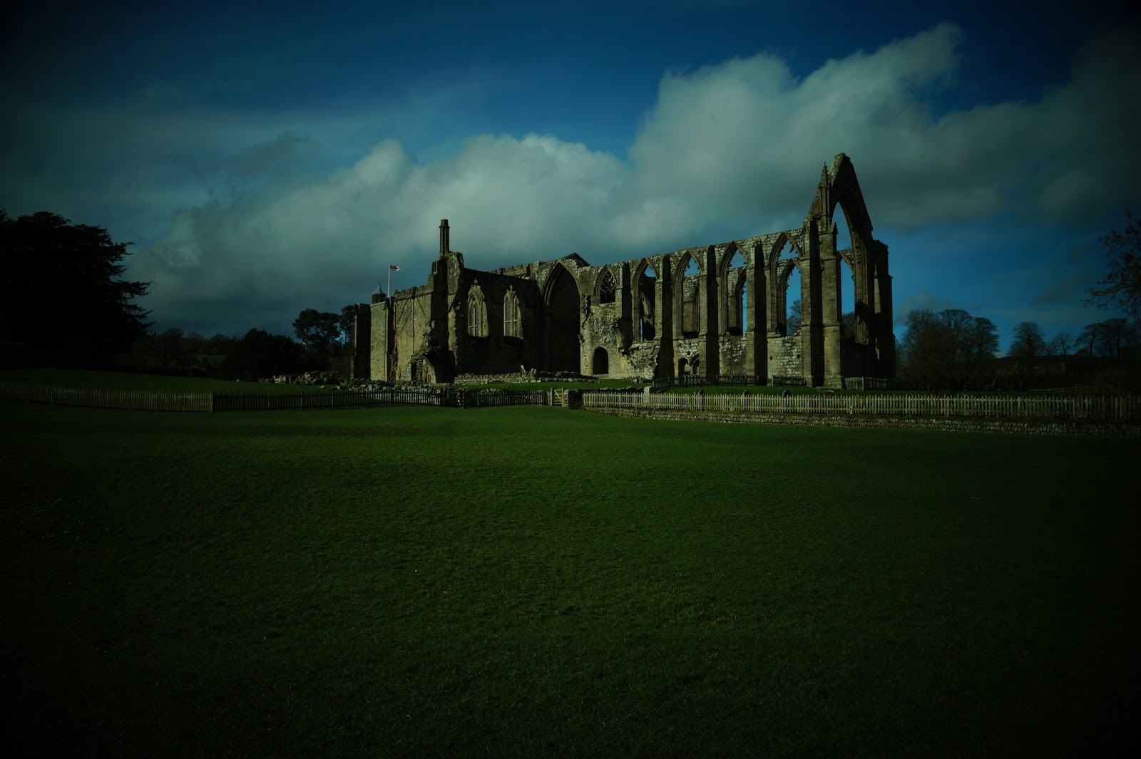
Walking through the mud was heavy going, but the sky was beginning to clear and ahead of us, we could see the ruins of Bolton Priory, looking lovely in the sunshine.


After crossing the field next to the Priory (and taking plenty of pictures), we made our way across the river on the track and decided to stop there for lunch, sitting on the wall separating the bridge from the river. 


From there on, we walked on mostly decent paths through the Bolton Estate, eventually arriving at a tea room near the car park access to Strid Wood, where we stopped for some refreshment. We walked through the woods on clear and pleasant tracks. This was a really pleasant part of the walk.

Oddly, we passed a fallen tree trunk that had been covered with coins – they had been pressed or hammered into the wood and there were literally hundreds of them – very strange. 


We also passed a make shift kind of hut that served as some kind of shop for someone who made things (garden ornaments mostly) out of wood. It was closed (as closed as something that has nothing but a tarpaulin for a roof can be), so we peered in from the outside at some of his creations.


The river narrowed and the amount of water entering the gully was tremendous – but the water coming out the other side did not seem to match the amount going in. a nearby sign cleared up the mystery for us – there is a huge cave underground at the point where the water enters the narrow part, the depth of two double decker buses, so the water falls into a huge hole before coming out the other end.


Soon after that, we came to a place where we had to cross the river – on a crenellated aqueduct – very fancy. [This was where I changed the camera settings - as you can see, it was a much lighter day than it seemed!]


Then on the opposite bank, we continued through several more fields and the inevitable mud. Some parts of the path were so wet, we had to make large detours to avoid the worst parts. But not too far on, we arrived at Barden Bridge and Sandra’s vehicle. 


After getting into the van, we started to drive back to Ilkley, but not before we stopped briefly to take some pictures of Barden Tower, which was much easier from the road than the fields. I had seen it briefly in the trees and high above where we were walking, but there wasn’t a good photo opportunity. The Tower is a ruin but the building next to it, which had been a priest's house, was now a restaurant. I did leave some muddy footprints on one or two of their flagstones (oops).


All that was left for the day now was to drive back to my van then drive separately to Bolton Abbey Caravan Park, where we were to spend the next three nights. There is one part of the drive to Bolton Abbey where I wondered if I would actually be able to get through and if not, was there another way round that wasn't miles out of the way? This is a narrow archway on a sharp-ish bend. But slowly (first gear) I did manage to get through and arrived at the camp site. I was just about to go into the office, when a lady came past me (she turned out to be the owner/manager) and said 'Thank you for pulling over - that was me you let pass on the road back there'. I had pulled off the road into the mouth of a driveway to allow a car to pass because I am big and cumbersome in my motor home. I guess that put me in her good books then! Shame about the absolutely filthy dog!!


Once again, tea and an early night, so we could be fresh for setting off tomorrow. And this time, I had no trouble falling asleep.

Tuesday, 11 April 2017

Dales Way 1 Sunday 19th March

Dales Way 1

Sunday, 19th March

A few weeks ago, Sandra, a friend from Shropshire contacted me and out of the blue, asked if I would like to walk the Dales Way with her some time in March. The Dales Way is a long distance trail, for those who don't know, that runs from Ilkley near Leeds all the way to Bowness-on-Windermere almost on the west coast. Depending on what you are reading, the total distance is 82 (start sign), 84 (sign painted on a bench) or 79 miles (the guide book), so take your pick how long it actually is!

Well, we settled on a date to start and that day will be tomorrow, 20th March. In the meantime, we had a planning session, working out how far we would walk each day and how we would manage the vehicles. The plan is that we will both have a vehicle – mine would be the large and somewhat cumbersome motorhome (no power assisted steering makes it very heavy and unwieldy to drive) and hers would be a much smaller single person camper. We would set off each day with both vehicles, drive to the point where we were to finish walking for the day, then drive back to the start in the other vehicle. We booked campsites – some with facilities, some without, but being without facilities would not be the end of the world, as my van contains a bathroom of sorts – a toilet and shower at any rate. Unfortunately, some sites were not available and so we booked one site for the first night, a second site for the next three nights, then another for the following four nights and a final site for the final night. That of course meant that driving to the end of each day’s walk got further and further from the campsite – and, of course, the long drive back at the end of the day. It wasn’t ideal, but we could manage!

So the day finally arrived (today) that we would both drive to Ilkley where the walk stars arriving about 5-ish.

I was relying on my satnav. My old satnav was quite sensible. If you asked it to take you the shortest way, it might take you through industrial estates and tiny lanes, but if you asked it to take you the fastest way, it stuck to sensible roads. Not so my current device! It really needs to learn that just because a road cuts off a corner to save a nano second does not mean we should use that way. It also needs to learn that just because a road is labelled ‘60mph’ does not actually mean it is possible to travel at 60 all the way along it!

Anyway, I set off. To start with, everything was fine – motorway and major A roads. But then just before Harrogate, at Killinghall, it sent me along a much smaller road and off along the A59. Sounds pretty good, but it takes you over Blubberhouses Moor, which is steep and narrow. Eventually, I arrived at Swinsty and the satnav said to turn left. I looked at the road (if it could be called a road) to the left and thought, ‘What? Up there!?’ But I did as I was told (I’m pretty obedient really, even to a machine) and turned left up one of the steepest little roads imaginable – first gear job in the van! If that wasn’t enough, a bit further on, it told me to turn right – down a road that looked like the van wouldn’t even fit! And where did I end up? Back on a more major road that I would have been on had I continued straight instead of turning left by the reservoir! Grrr!

Finally arrived at the campsite about 5pm. This was one of those sites without facilities and there were only half a dozen pitches. The one at the far end was empty, so I presumed that that one was ours (it was). There was no-one about and the notice said to visit the house after 6pm. About 10 minutes later, Sandra arrived.


We decided while it was still just about light, that we would walk the mile or so into Ilkley to find the actual start of the walk. We knew it was somewhere along the river by a bridge, but there was more than one bridge – not that we knew that at first. We stood by the main bridge and were quite disconcerted to find no start sign. We had expected that something as popular as the Dales Way would have some indication of where the start was. We decided to walk back to the campsite along the river – and that was when we happened upon the other bridge – the ‘old’ town bridge – and there was the missing signage, saying ‘Dales Way 82 miles’ and pointing helpfully down a narrow track heading west. There was a good deal of street parking available near the path so we decided we would park there when we started tomorrow morning.


On returning to the campsite, we paid our dues and turned in for an early night – so we could have an early start in the morning. Must have been the excitement of actually starting the walk, or maybe it was that I ate my tea shortly before going to bed, but whatever the reason, I didn’t actually get to sleep till 2am! Never mind, as the saying is, tomorrow is another day!

And the interesting thing about this venture was - we had decided to bring Storm along with us!


Saturday, 8 April 2017

Apedale and Harkerside Moor

Cicerone Guide: The Yorkshire Dales: North and East

Map: OL30

Distance: 9.8 miles

 
I do have another blog post (or several) to write up, as I attempted the Dales Way with a friend recently – but I will write that (or those) next time. For the moment, I walked about 9.8 miles around d Apedale today. Why so precise? Well, that’s what the guide book tells me the distance is ;)

I parked the car, changed into my boots and set off by ten thirty. There is a large flat gravel area just off the road on the west side of the Grinton to Redmire road, so I parked there. 


Sorry, for some reason the photo is a little dark - even on auto, the camera was having trouble with the bright sunlight today.

The footpath starts slightly to the north of the parking area, by about 100 yards or less. The path sets off heading south west and up hill. If you have read many of my posts, you will know by now that ‘up’ is not something I relish. But it wasn’t too far and I was fresh as a daisy this morning.


The path was none too clear, but the grass was slightly darker than the surrounding areas, so I had no difficulty knowing which direction to take. It was also wet underfoot! 


As the ground rose between ‘hedges’ of heather, it became drier, until I was walking on a gully full of rocks. It might possibly have been a dry stream bed, but I am not sure. Anyway, just after I left the rocky part, I met someone coming the other way – on a bicycle. Rather him than me over those rocks :O This is looking back to the rocks I had just passed:


From a distance, I could see what I thought was a signpost. On closer inspection, it turned out to be a bird table! Odd, you might think, but these are grouse moors and the birds are not just left to fend for themselves; they are carefully managed and well fed.


Once at the top, the path arrives at a point where several fences meet. 


Once at the top, I took a panorama of Swaledale behind me


and another of Wesleydale, after going through the gate.


Unfortunately, it was rather hazy!

The path then begins a gentle descent, getting gradually steeper – but never too steep – down into Apedale, to a little place known as Dent Houses. I saw several areas of grouse butts and a couple of geese, making the best of the weather and the lack of gunfire!


I met my second cyclist who had just cycled up from Dent Houses – while I said it wasn’t steep, I wouldn’t enjoy cycling up there! Shortly after the cyclist, I met a runner who had also just run up from Dent Houses :O He still had enough breath left to actually speak to me!!

Descending the hill, I had now crossed from Swaledale into Wensleydale. Dent Houses is actually a crossroads of paths, where there is a barn and another building, which I think is now either a shooting hut, or a bothy – I didn’t go to investigate, as there were other people wandering around the building and I prefer my own company.


At the crossroads, I turned right and headed along Apedale. The valley grew narrower and the path grew steeper. At one point, where there were indications of former mine workings, there was a path opposite, which I wondered where it went, zigzagging up the hill. I didn’t go exploring, but later, when I checked on the map, it would have been something of a disappointment, as it only went to the top of the hill, then stopped. Presumably for the ever increasing number of grouse butts that litter the landscape.


At one point, the path is so steep it has been laid with concrete and rippled, to give some traction to any vehicles coming along there. 


As is often the case, when I got to the top, I realised it wasn’t the top at all, but there was another ‘top’ further on, though less steep to reach. I finally arrived at the ‘gate’ which is the watershed between Wensleydale and Swaledale. 


The guidebook says that there is a wide vista laid out before you, with views to Gunnerside and beyond. Pity about the haze – the views were less than spectacular.

The next landmark was a ‘huge heap of stones’. The trouble is, the guide book didn’t specify which side of the path this heap of stones was located. I found a huge heap on the right hand side of the path and indeed there was a small, almost non-existent stream just past it.


However, there was no sign of the supposed path, so I spent a fruitless ten minutes trying to find it. I finally came to the conclusion that the book was using ‘Yorkshire miles’ and the 800 yards it mentioned was in fact quite a bit further. So I continued along the main track, looking for a not too clear footpath to the right. I needn’t have worried. The huge heap of stones was in fact humungous! 

This is more like it:


It was named ‘Morley’s Folly’ in honour of some man in the nineteenth century who probably decided to make his fortune digging out his wealth from beneath the dales’ floor. It seems however that his venture failed and all he managed to dig out was a rather substantial quantity of stone, which has been left in a heap next to the path. The faint path turned out to be a proper track – the difference between a book written in 2009 and a map printed in 2016! 

Turn right along a faint path!!

And due, of course, to the never ending grouse shooting – there is a lot of money to be had in grouse obviously and a series of tracks – well made tracks at that – has sprouted up all over these parts. Maybe Mr Morley would have had better success had he made his venture into grouse instead of lead!

According to the guide book, there is a cairn right on the track. I stopped somewhere near it to have my lunch – but it was about 150 yards behind me, as the track does not follow the line of the old path. Rounding a corner soon after, I saw the remains of a rather splendid lime kiln to my left. Originally, the path went past the front of it, but the new track passes behind it. Once past it however, there is another track that follows the old path so you can still visit the monument and see what it looks like. Unfortunately, the sun was in the wrong place (don’t get me wrong here – the sun was in the sky where it is meant to be; it was just shining straight into my lens when I wanted to photograph the kiln).


Not long after this, I encountered a shooting hut. Hopefully, I tried the doors – yes I could get into the room where there was a table and chairs; sadly, the other door was locked and probably kept exceedingly safe the very facility I needed - the toilet! Do they think hikers are going to steal it or something? (Just to clarify, I do know why they keep them locked!)


Beyond the hut, the path forked. Now I have done this path before, but from the other direction. Last time, I arrived at the fork from the left. This time, I branched right and started the long and eventually steep climb up onto High Harker Moor. The effort was well worth it – or would have been if the views had been less hazy. The top is quite flat, but even up here, there was evidence of plenty of past mine workings.


Once past the workings, the path continues, before beginning to drop down into Grovebeck. This was where I met my third cyclist, but he didn’t seem as athletic as the other two had been. From my high vantage point, I could see two other tracks to my right and began to worry that I ought perhaps to be on one of them, instead of the path I was actually on. But I allayed my own fears, telling myself that I had passed the relevant markers. The path dropped downwards and I eventually reached what looked like a crossroads of sorts, though one track was merely grass. I took the right turn and then tried to second guess myself again, as I was clearly now travelling south. After checking the map carefully, I realised yes, this part of the path did go south and was in fact one of the two paths I had seen from higher up.

After a mile or two, the path started to bear to the left, over a small stream - Grovebeck Gill:


and when it had passed a stone built hut (same issue as with the last one – no access to any toilet facilities), 


we were walking in exactly the opposite direction and I was now on the second of the two paths I had seen earlier! At this point, I met my fourth cyclist – at least, I thought he was the fourth, but as he passed me, he said ‘Hello again’, so I presume he was one of the ones I had already met. I deduced that he was probably number 2, as his bike was not orange (number one) and he wasn’t wearing blue (number 3).

Not long after this, I arrived suddenly and unexpectedly at the road. I had seen cars on the road earlier, but it had seemed further away. But what I hadn’t taken into consideration was that the road on which I had parked was at right angles to the more major road past Grinton Lodge; the road I had seen from a distance was in fact the one past the Lodge.

Anyway, a short hop skip and a jump along the road (well, more like a plod really), I could see the car and was happy to reach it.


As an aside, I drove into Reeth after reaching the car to use the facilities there. Another woman was just entering as I arrived and I thought, ‘I’m sure I know that face’. So I waited for her – and she obviously recognised me too. But it has been some time since we last saw each other, so it took a while to work out how we knew each other, as neither of us could actually place the other. Anyway, it turned out we had worked together briefly several years ago and she attended the church that had started the one I was then attending. So Ruth, in the unlikely event you are reading this, nice to meet you – and yes, you meet the most unlikely people in the most unlikely places!!