Map Explorer 308
Book: Cicerone Guide, Walking in County Durham, Walk 2
It was a beautiful autumn day, with clear blue skies and plenty of sunshine, albeit a little cool. The breeze was minimal. Storm and I drove (well, I did the driving!) to a leisure centre on the edge of Ushaw Moor, where we parked for the start of the walk.
The first hour or so was nothing to write home about, as the saying goes. We walked through a housing estate,
then walked down a country path between fields,
and came to another village, Broom Hall,
The path came out opposite Broom Hall church, St Edmund, which, unusually, is made of brick.
We turned left onto the road and proceeded up the hill, looking for a school. The path was supposed to be opposite the school gate. We first saw a 'school' sign, but there was no sign of the school, so we kept walking, until we actually exited the village. Realising we must have missed the path somewhere, we checked the map carefully and then turned round and headed back to near where we had seen the signpost... and there in the hedge was a gate leading into a field, with a barrier on the road edge to protect people coming out through the gate onto the road.
The inauspicious 'school gate'
The sign saying 'bridleway' that we had expected to see at the road end opposite was missing.
Turning up the road, we crossed over and set off across another field, which contained an odd metal item; I am not entirely sure what it is/was, but it looked like it might have been part of a children's playground at one time.
Just don't ask me what it's for!
At the bottom of the field, we passed through another housing estate, then turned left at the bottom, to follow a more country path, passing behind the houses of the estate we had just come through. At the end of that, we turned left, then followed a road which became increasingly track-like and at last we were in open countryside.
The track meandered down towards the river Brownie, crossing the Lanchester Valley Railway path on its way. The walk actually takes the Railway Path, but there is a detour down to the river, across the bridge and up a grassy knoll, to find an old ruin, known as Beaurepaire.
The bridge and the grassy knoll behind it - you would never believe what is on top of that hill!
According to the guide book, Beaurepaire was built in 1258 for Prior Bertram de Middleton. The ruins are quite extensive and show the size of the original house and outbuildings quite clearly. If you are interested in knowing more about the place, you can find it here.
It was only a short walk back to the Railway Path, where we turned off to the left.
Railway paths criss cross Durham like patchwork and are great for walking routes - if you don't mind flat tacks (steam trains didn't do well with lots of inclines), and lots of company, in the form of walkers, joggers, cyclists and other dogs!
Long, straight and very flat
This is quite an extensive grassy area, laid out with several picnic tables.
I had already had my lunch by this time, at one of the many benches along the route, so we didn't stop.
Near here, the mainline railway passes very close to the footpath.
The area is also where three railway paths meet - the one I was already walking on of course, then the Deerness Valley path and the Brandon to Bishop Auckland path. At this point, I took the Deerness Valley path. If I had not left the car at Ushaw Moor, it would have been interesting to take the Brandon to Bishop Auckland path, as that is the path that runs quite close to my home.
We walked along the top of an embankment then through a long cutting, where the railway engineers had cut a flat path through a hill. At one point, the clouds began to gather and it looked like we were due for a soaking.
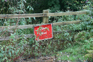
At the end of the cutting, I looked out for some steps on the left, where we were supposed to turn left and head down towards the river, before returning via a different path to the track. Unfortunately, when we found the steps, we also found this:
Yes, that does say 'footpath closed' - with that fence, it looks permanent
There was no other way down, so we continued straight along the path we were on, then turned right to return to the road at a point opposite the leisure centre where we had left the car. Altogether, we had cut off about 2 miles of the walk. Still, it had been a good day and the rain had held off, so we weren't too disappointed.
And we had seen some wonderful evidence of autumn on our travels:


No comments:
Post a Comment