Today’s walk
took in two Dales, walking from Wensleydale over the moor top to a second dale,
Coverdale, then back over a different moor top, back into Wensleydale. This
will be my last walk without Storm for a while, I hope.
Guide book: 80 Dales Walks, Paul Hannon, walk 64.
Map, OL30
Guide book: 80 Dales Walks, Paul Hannon, walk 64.
Map, OL30
It was a
lovely day as I drove to a tiny lane just outside West Burton, seven miles from
Leyburn. The plan was to park at Cote Bridge – not a village; just a couple of
houses near a small bridge over a stream, that feeds into the Ure near
Aysgarth. However, there was nowhere to put the car near the bridge, so I
continued up the lane (according to the map, it is called Whiterow Road) till I
came to a large lay-by. Actually, I wasn’t sure if it was a lay-by or a ‘passing
place’ (a widening in the road to allow cars to pass one another when
travelling in opposite directions on narrow country lanes). It was quite long,
so I parked as far to one end as was practical, thus leaving enough space for a
car to pull in if necessary.

It was 11.15
by the time I had put on my boots and pack and set off. I headed up the hill
away from West Burton.

To my left was the moor I was about to climb up; to the
right was a valley with a river, Walden Beck, in the bottom of it.

The trees
were particularly spectacular in the autumn sunshine.


In the distance, I could
hear gunfire – but not grouse shooting; I believe the farmers were out shooting
rabbits.
The lane
climbed steadily, coming to a sharp left hand bend, before very soon turning
right again, passing through a short tree lined stretch. At the end of the
trees, I reached a signpost pointing off to the left and onto the moor top. The
guide book said the post indicated Horsehouse, but it simply said ‘Public
Bridleway, Fleensop Moor. If you haven’t guessed, yes I am using the same guide
book as the last walk, which was printed in 1989, so things are sometimes
different. The signpost was one of those things!

There was a
good gated track heading up towards the moor top.

After passing through a gate,
right on the top of the hill, the path levels off and comes to a fork. The
guidebook says ‘be sure to take the less clear left fork’, however, there is
now a signpost at the junction indicating the left fork as the main bridleway
and the right fork is now the less clear of the two paths.

Apparently,
this area was a former mining area, but there was little or no sign of that
now. There were plenty of signs that grouse shooting is carried on here –
grouse butts and a good track for driving the shooters onto the moor. It has
the added benefit that walkers like me have a decent track to walk on.
I came across a very sick rabbit on the path. Its eyes were swollen and it didn't move as I approached. This is a result of myxomatosis. 'Myxy' as it is known is not indigenous to this country, but was introduced to control the rabbit population. If you want to read more about it, then look here.

The
terrain is very different from Swaledale – while there is some heather, it is
sparse and the land is covered with bracken instead. At this time of year, the
bracken is brown and orange and in the sunshine looked lovely.

Sometimes I could have been forgiven for thinking I was on the Pennine way though:


I do love being
on the moor tops by myself. The climb is always worth the effort. Once again, I
had the moor entirely to myself, though I did see the occasional footprint in
the mud, indicating that someone else had passed this way before me.

After some
distance, I came to the head of a steep sided narrow valley. A stream ran
across the path and disappeared down the gorge.

The guidebook calls this
Fleemis Gill, but the map indicates it as Coal Gill. Not that it matters –
there is only one stream to cross and the track is still very clear. I crossed
a few steps upstream as the path was covered to a distance of about six or more feet –
too far to jump and too deep not to get my feet wet. Upstream the water track
was very much narrower and easy to step across.

After passing
through another gate and between some more grouse butts placed across the track,
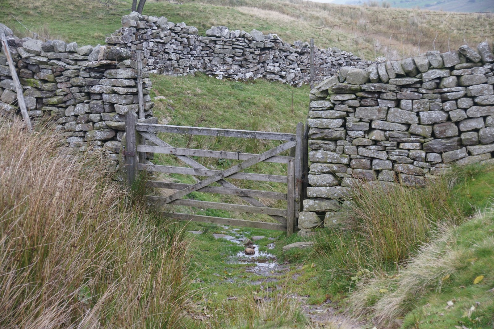
I came to a wall.
The path veered off to the left and ran alongside a stone
wall. The book said to follow the wall and the to pass through the first gate
you come to. That left me in a bit of a dilemma, as just where the path turned
left, straight ahead was a stile built into the wall. Having been caught out before
by not following the guide book instructions, I decided to ignore the stile and
follow the wall to the gate.


Once through
the gate, I was supposed to be in a ‘pasture’. Looking in front of me, I had to
laugh! If this was a ‘pasture’, I’d hate to see what a swamp looked like!!
There were small patches of grass, but the rest of the field was covered with
dense reeds and the ground beneath was very wet.

The field sloped downhill, so I
made my own pathway through the reeds (and yes, I managed to keep my feet
dry!), heading to the bottom left corner of the field. There was a stone stile
built into the corner, but the area in front of it and also the area just over
the wall was very wet. So I simply walked over the wall where it was pretty
much non-existent any more.

You can just make out the flat slabs built into the wall to enable climbing over it.

The hole in the wall, where I walked through.
I walked
through three such fields. In the third field, there were two gateposts – but no
gate or wall or fence.

On the other side of the gateway was a track sweeping
back up the hill to my right. I think it might have been a continuation of the
lane I was about to take. If I had gone through the stile at the top, I have little doubt it would have joined this track.
In the bottom corner of this third field was a gate,
which led into a lane with walls and trees on either side. A stream ran down
the right hand side of it, but the water wasn’t going to be confined to the
stream bed! No, some of it ran straight down the track as well! This lane, which
I believe to have been a ‘green lane’, led down into Horsehouse. The going was
quite difficult – the track was not well maintained, though it was laid with
stones. But the stones stuck up at odd angles and they couldn’t always be seen,
as the trees had shed their leaves, hiding any potential trip hazards.


I failed to take a photograph of the leaf covered part of the lane, for reasons which will become apparent shortly.
I reached
the bottom without mishap thankfully and entered the small village of
Horsehouse. Right in the middle is a pub, the Thwaite Arms. Diagonally opposite
was the church; diagonally opposite the other way was a bench. As it was now
2pm, I sat on the bench in the sunshine to have my lunch.


Part way
down the green lane, my camera had decided to make the oddest rattling noise as
I turned it off, along with a long (too long considering the camera was now
OFF) buzzing sound. I had noticed earlier that I had been having trouble with
the focusing – it wouldn’t allow me to use manual focus and it was having
difficulty using auto focus. After lunch, I turned it on to see if it was just
an oddity – unfortunately, it made the same noise again when I turned it on and
it continued for a while after I turned it off again, just like before. So the
rest of the photos were taken on my phone.
From Horsehouse
to Carlton was low level field paths, partly alongside the river and then
through fields to Carlton.


Road walking was minimal. I met several interesting
people during this section. The first people were a couple – she was reading
the map; he was reading some instructions that set out where they were going. Overhearing
his description (“take the path behind the pub and then walk through what looks
like a garden to reach a gate into a field”), I asked them if they were going
the same way as me, as it certainly sounded like it. They showed me their map
and yes, they were, at this stage at any rate. They set off in front of me,
walked round the side of the pub, then carried on straight ahead between some
houses and into a garden. Checking my map and instructions, I set off round the
back of the pub (not the side) and continued down the lane to reach a garden
with a gate clearly visible at the far end of it and a footpath sign partly
hidden by an apple tree! The other couple came along behind me. I pointed out
the footpath sign; then they accompanied me across two or three fields and past
a small barn. They made the comment that I was doing all the hard work of
reading the map and they were just following! We continued together until we
reached a bridge over the river – they turned right and I continued along the
river bank.
Shortly
after this, I reached a part where the path originally ran between the fence and
the river, but this looked impassable,

so I was pleased to see a stile and
footpath sign telling me to walk through the field instead – much safer! As I got
to the other end of the first field, I realised I had company behind me. At first
it looked like two men, but it soon became evident that there were also two
women with them, but a little way behind. They lived in Carlton, so they knew
the path well and where they were going. So I accompanied them most of the way
from there, through Gammersgill and onto a lane just outside Carlton. They continued
up the lane whereas I decided to follow the guidebook and cross the fields. They
were only a few feet in front of me when I emerged again onto the lane at the top
of the field.
I stopped to
take a photo of the sign as I entered the village, just before a sharp right
hand bend. My travelling companions disappeared round the bend and I didn’t see
them again.


Right on the
bend there was a lane heading off to the left.

I was pretty sure that was where
I was supposed to go, but I decided to check the map before I set off. A man on
crutches had come down to the junction to sit out in the sunshine on the bench
on the corner opposite the junction. As I peered at the map, he called across
to me to ask where I was going. I joined him on the bench and showed him on the
map. He confirmed that I was indeed supposed to head up the lane to the left. He
told me there was a junction a little way along the lane – I could either
continue along the lane, or take a track to the right. He said there was a
signpost at the junction, but it ‘helpfully’ says West Burton both ways! I checked
in my guide book, and it said I should take the track. The man told me it was
quite steep, but the climb onto the top of Carlton Moor was worth it as the
views are spectacular. He said the path was fairly clear and easy to follow, if
a little steep coming down the other side.
His foot was
in plaster, so I asked him what he had been doing. He had apparently slipped on
the stepping stones at Gammersgill Beck and broken the bone in the top of his
foot – last June!! They have told him he might be able to go back to work in
January! He works with sheep (farmer or farm worker, I’m not sure), so his foot
is a real problem for him. The bone is not knitting together either, so he is
having some physio to try to strengthen things, but he is facing the prospect
of an operation to fit a plate. He used to be a Councillor for the area and has
complained many times about the stepping stones. There is a ‘helpful’ sign
saying not to cross the beck when the water covers the stones, but that, as he
pointed out, is common sense! The council has put mesh over the stones,
supposedly to make the grip better underfoot, but the stones are mushroom
shaped and so the mesh is too, making virtually no difference.
It was now
after 3.30pm, so I took my leave and set off up the lane. It wasn’t long before
I reached the place where the lane and the track diverged. Looking along the
road and then up the track, despite the track being quite steep, there was
really no contest – the moor beckoned.


The climb up
was definitely hard work, but it wasn’t too long before it levelled off to an
extent, though still heading upwards. In fact, the upwards trend continued for
a good couple of miles, but the views were indeed spectacular.


However, the sun
was beginning to disappear behind the hills and I knew the daylight was
limited. It was about this point I realised that the signs had said ‘West
Burton, 4 miles’ – that meant I didn’t actually have that far to go and thought
I should be able to make it by 5.30. Yes, it would be dark by the time I
reached the car, but as I had a torch with me this time, it wasn’t going to be
an issue – and I had been assured that although steep, the descent was easy to
follow.

After climbing
upwards for about three quarters of an hour, I came across a building
surrounded by trees. This was Howden Lodge, a shooting/hunting lodge. One website
describes it as ‘an impressive shooting lodge’; it made me smile because
compared with the ones I have seen in Scotland, it looked like a brick built
garden shed at worst, or a chapel on the moor at best.

After turning
right past the Lodge, I continued to climb upwards to the top of the moor. As I
have said previously I am not fond of ‘up’; this was beginning to get somewhat
tedious. However, finally, I reached the ‘brow of the hill’ and was able to
look down into Wensleydale and towards where my car was parked.


Lights in the distance, showing where I am headed.
The sun was
almost set, but there were some beautiful streaks of red light in the clouds
opposite the sun. Then in a last fling of glory, the bright red and gold of the sun lit
up a gap between the clouds in the west.


I got my
head torch out and continued along the path, now heading quite steeply downhill
– though not quite as steep as I had expected. The guide book says the track ‘throws
itself into steep descent’. Although it wasn’t as steep as I thought, it was
still difficult to navigate. For one thing, the light was fading and finally
did fade completely before I reached the end. Even with the torch, it was not a
comfortable descent. For another, there had been some heavy rain in the
previous two or three days, so the track was running with water, over the gravel
and stone bed. I resisted the temptation to hurry and made steady progress
downhill. A few times I disturbed roosting grouse (do they ‘roost’ on the
ground?) and whole flocks of them rose into the air as I approached.

The last of the light over the hills, silhouetting the trees on the skyline.
Finally, I reached
the lane where I had parked the car. Unfortunately, parking half way up the
lane meant I now had to walk uphill for about half a mile. As it was now
completely dark, I couldn’t see any landmarks, so I had no way of knowing how
close I was to the car. As it happened I wasn’t that far away and as I rounded
a bend, it came into sight.
Great walk –
not one to be done the other way round as the steep climb down into Cote Bridge
would be pretty difficult to go up instead. 11.5 miles all told and
exhilarating. I had the moor to myself in both directions and met some
interesting people in and around the villages. Couldn’t really ask for more,
except for having Storm with me perhaps J
This is
probably going to be my last long walk until next spring, unless I can get to
the start point much earlier. I really need to be back at the car by 4pm, or
earlier. Even with a torch, the conditions underfoot can be difficult if not
treacherous and it makes the going much slower. I had hoped to be back by 5.30
at the latest, hopefully sooner. It was, after all, only 4 miles from Carlton
to West Burton. In fact, it took me 2.5 hours, what with the ‘up’, the dark and
the slow descent. So over the winter I will probably only do between 6 and 8
miles.