Dales Way
Revisited 2 Monday 17th April 2017
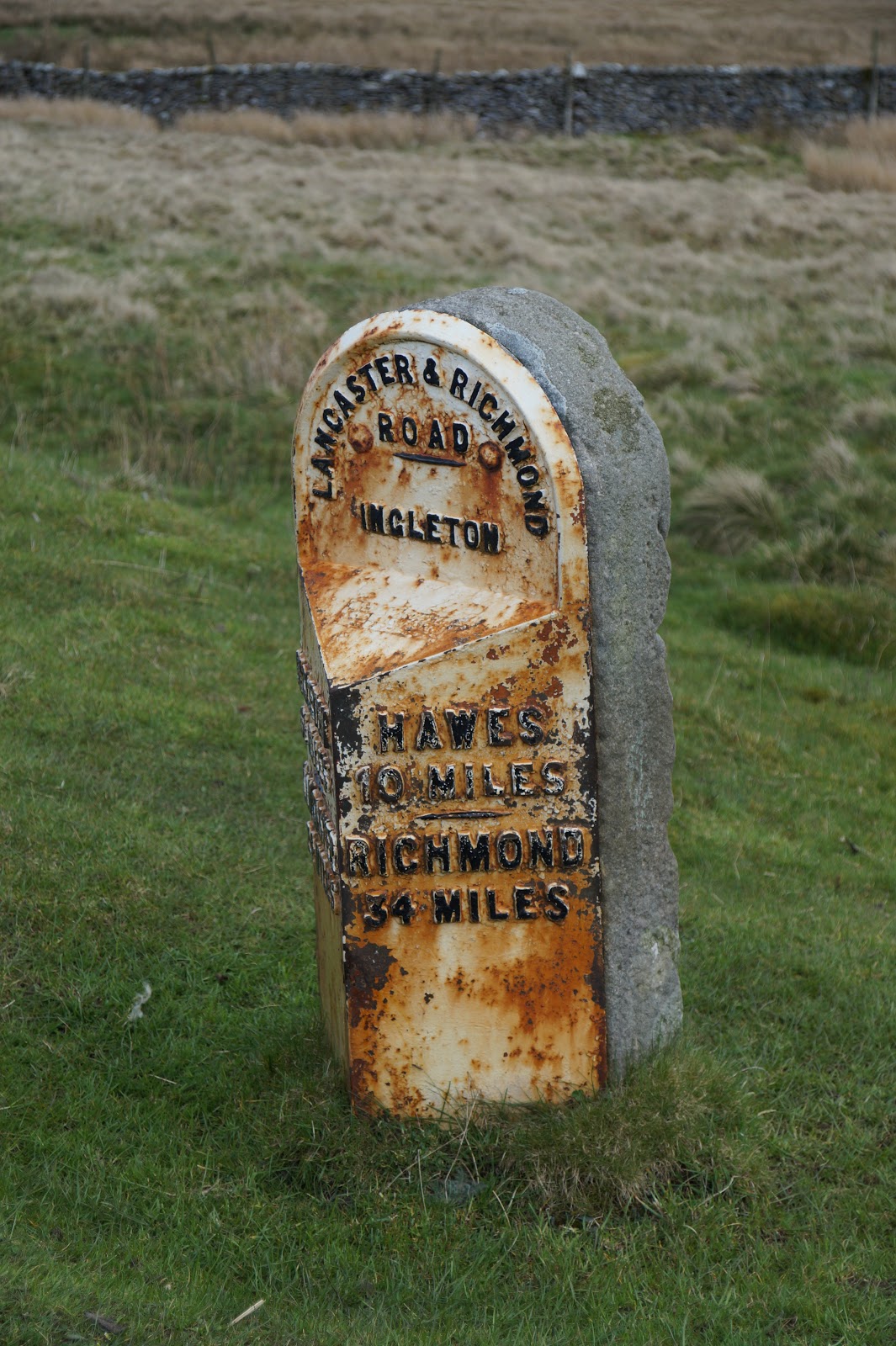
Map: OL2
Beckermonds
to Ribblehead
Now this is
a section of the walk neither of us did the first time. If you remember, we got
to Beckermonds and Sandra walked back via the road to fetch the car, because I
was having a loopy moment.
We arrived
at Beckermonds at 11.30am or so and I set off straight away.


The first part of
the walk was on the road – the same road we drove last time, but last time
there was a lot of snow piled high at the sides of the road; this time there
was little but sunshine J

Sadly, even all the way out here, people love to dump their rubbish:

The route
passed Oughtershaw Hall – and what a noise just beyond it. The sheep were
baa-ing and making an enormous racket!

You can just make out the hall through the trees


A closer view of the Hall. This was where we (OH and I) had once looked at buying, as a business venture, but sadly it was not viable. It seems now to have been converted into more than one home.


In the wall
of the house nearby, there was a Georgian post box, so I photographed it:

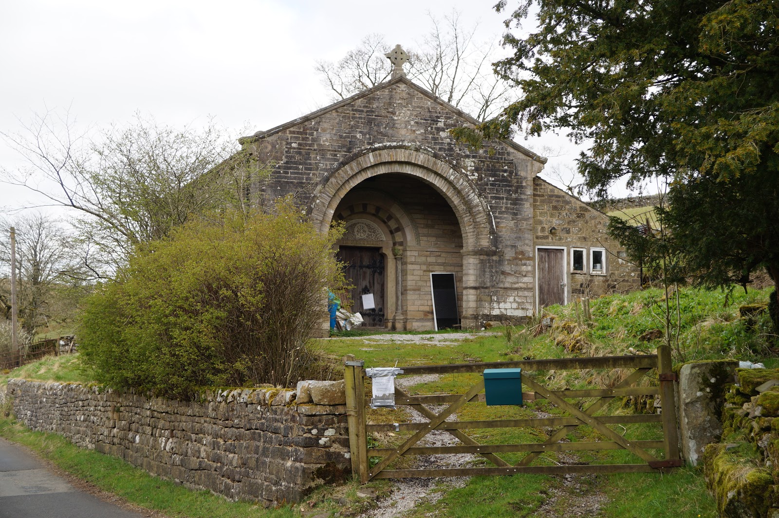
Opposite,
there is an old chapel. There was a notice attached to the gate announcing that
planning permission had been applied for. The place has been disused for many
years, so I guess turning it into a house would be a good idea and would
preserve it. It has a rather nice frontage:

Oh, and a
red phone box as well J

But at the point where the path left the road, there was actually a Victorian post box, so I photographed that one as well.

The path was
easily found as it was a broad track leading to a couple of farms and was well sign posted.

The junction
where they separated there was a Dales barn

And also a
Celtic cross – not original, sadly.

The track
followed the river all the way to the first farm


When I
reached the farm, even though I had not been walking for long, I stopped for
lunch on a convenient wooden beam perched outside.


So far, I
had met two couples and three cars had passed me heading for the road. While I
ate my lunch, a lorry parked nearby kept its engine running the whole time. It was
not exactly a quiet day! Once the lorry had left, however, silence descended for
a time, except for the birds singing. A heron flew by, but I didn’t have time
to photograph it unfortunately.
I had been
involved in an online discussion recently about whether or not the country code
said to shut all gates, or whether you are supposed to leave them as you find
them. My contribution was that I’m sure the farmer would prefer to open a gate
he had left open and someone had shut, than for it to have been left open by
some irresponsible hiker or other and all his sheep to have escaped. Anyway, I came
across this sign, which indicates at least this
farmer agrees with me!

The track
continued all the way to Swarthghyll Farm.

As I walked, I counted the number of
vehicles and other things that passed me – altogether, there was the one lorry,
NINE cars, five people and a dog, not to mention several cyclists. When I
arrived at Swarthghyll Farm, I realised why there was so much traffic – it was
quite a thriving business – and a conservation site, which was rather ironic.


Once past
the farm (I think the path has been re-routed through here as it didn’t follow
the guide book exactly and the way through was rather convoluted),

the track
vanished suddenly and became a narrow field path – and it was muddy! I dread to think what it would
have been like on the previous occasion after all that rain we had had.


And yes, that is the path!
The next
point of interest was supposed to be ‘end barn’. I thought I could see it in
the distance

and indeed, I reached a barn, but it was not clear if this was the
one intended or not. There was however a plethora of signage attached to it,
just in case you wanted to go the wrong way!


The
guidebook also mentioned that just before the barn was the ‘watershed of Britain’
which I had to cross. Well, that wasn’t obvious either. There were several
streams flowing from right to left into what looked like a huge land basin, but
nothing that would shout ‘this is it – the watershed of the whole UK is here!’
Some of them were quite full and I had to walk through the water. I suspect
that had we tried it on the earlier occasion, one or two might have proved well
nigh impassable.


I passed behind
the barn, steadily climbing upwards all the way and now heading to Cam Houses. There
were plenty of signs, so it was not hard to follow the track – except for the
mud.


I wish they'd make their minds up - is it 'Dalesway' or 'Dales Way'?

There were several stiles I was meant to climb over too, but as there were
gaps in the walls right next to them, I decided not to bother!

I really do hate
those stiles that are double gated – ie a gate on both side at the top of a
wall. Getting up and opening one gate is not difficult, but if you happen to
have a dog with you, opening the second gate while balancing yourself and a dog
on the top is a. You have to hold open both gates, in opposite directions,
while getting yourself and said dog through a narrow gap – if you haven’t
already fallen off the top because there really isn’t room for both you and a
dog! Anyway, it was a moot point at this stage, as Storm was not with me at this point.

You really need two people to get across these if you have a dog with you!
I passed
through a section that the guide book described as ‘dark and gloomy’ passing
through some trees. Actually, it was bright and sunny and a scar on the
landscape – the foresters had already cut down the trees and the path was
clearly marked with gravel.

Just as I reached
a particularly twisty and muddy section, I saw OH and Storm in the distance:

She
hadn’t seen me though, so as she rounded the bed from one direction and I
rounded the same bend from the other direction, she noticed that ‘someone’ was
present and pricked up her ears. It only took a nano-second though for her to
recognise that it was me and she went wild with excitement.

Up ahead,
the Dales Way and the Pennine Way took the same route briefly.


The Pennnine Way
is notorious for being exceedingly muddy, even in the driest of weather, but
oddly enough, this was where the path returned to being a substantial track.


It
was an easy path from here, descending gently most of the way, and it wasn’t
long before I caught my first glimpse of the Ribblehead viaduct.

The parting of the ways:

The views
were simply stunning. It is here that you can see all three of the great
Yorkshire peaks, Whernside, Pen-y-ghent and Ingleborough. I have no idea which is which though!

There were some more sheep (of course) and a couple of random limestone outcrops:


The road
soon came into view, where the car was parked, just near a farm – quite close
to where I had left the van a few weeks ago in fact.


To complete
the day, we drove down to the viaduct and I took a few more photographs – well,
it is a famous landmark! Sadly no steam trains crossing it today, but still
pretty spectacular.