Lincoln’s
Inn Bridge to Burneside
8/7/2017
Well, to day
started out a bit oddly really. We drove to the start of the walk at Lincoln’s
Inn Bridge and OH said ‘Is this where you need to get out?’ and for some
reason, I thought we were at Milthrop Bridge (I know, they all look alike to
me!!), so I said ‘no’ and so he drove on across the bridge. Then it dawned on
me that yes, this was the bridge and so he had to turn round. Did you see the
size of those roads? Narrow to say the least, so turning round was no mean
feat! Still, he managed and took me back to the bridge. It had only been about
five minutes, so no time was actually lost in reality, but I was concerned that
maybe my blood sugar was dropping again, as that was really a stupid mistake. Anyway,
I set off past a signpost saying ‘Low Branthwaite ¾ mile’

The path
from the road headed into the fields to the west:

It was
overcast, but not wet, so ideal walking weather. The path wandered along next
to the river – this time the water was to my left. Through the trees I could
just make out a lovely waterfall:

…and ahead
lay more meadows and hills

…and, of
course, inevitable stiles along the way:

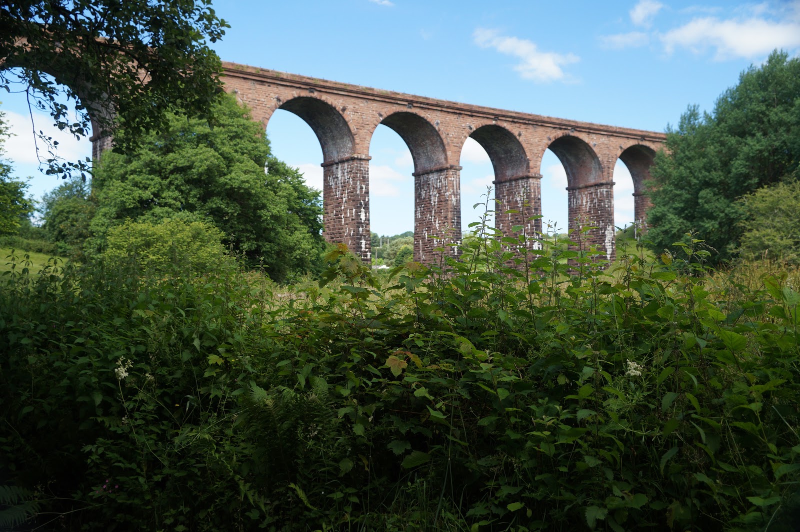
The meadows
headed for the Lune viaduct – so called because the river we
have been following since yesterday is the Lune. The viaduct is now redundant
and disused


I had to
walk beneath its graceful arches

The sun was
lighting it up better from the other side:


The path
then led upwards through a field full of sheep; another picture of the viaduct
from higher up the hill:

Ahead lay
the Howgills:

…and a lovely farmhouse nestled in the folds of the fields:

…followed by
views towards the hills of the Lake District

I walked
around the barn in the previous photo, following a footpath sign to ‘Hole House’

…and then
through the farmyard at Hole House farm

The path
leads through the farmyard and onto a road by a bridge over Smithy Beck and on
to Crook of Lune Bridge (yes, another bridge J )


The Lune
used to mark the boundary of the Yorkshire Dales National Park, but it does so
no longer as the Howgills were firmly annexed to the Park in 2016 (if I
remember that date correctly).

Once over
the bridge, a quick backward glance:

From the
bridge, I followed the road round the bend and up the hill, towards a viaduct. There
is no traffic along here, not least because there are road works at the bridge
which was closed to traffic owing to damage by floods some time before

The Howgill
fells looked particularly spectacular in the morning sunshine:

It wasn’t
long before I could see the viaduct I was aiming for:

Crossing underneath
the viaduct, I came to a road I needed to cross. Again, it was not particularly
busy, but I had heard one or two cars along it as I approached. There was a
large road sign and a Dales Cycle way sign, but the Dales Way footpath sign was
on the other side of the road on a gatepost


Still following
the road, I passed what had once been a post office; not what you might expect:

A panorama
shot taken facing back the way I had come, shows the Howgills and the Lowgill
viaduct:

As you have
probably noticed, I can’t get enough of photographing the Howgills J


Moving on, I
saw a lovely old birch tree, its branches seeming too heavy now for its elderly
trunk, so were resting on the ground

Ahead of me
lay the M6 motorway, which I heard long before I saw it L I know we need big roads to get all
the traffic from A to B, but sadly they are so noisy and a scar on the
landscape, a necessary evil and unavoidable

At some
point, I would have to cross the road (either under it or over), but not yet. The
path continued through lovely pastures towards Lakethwaite farm

I turned up
the track towards the farm, but just before the actual buildings is a signpost
turning the walker to the right and around the back of the barns.
Another view
looking backwards

…and another
looking forwards

After another
few fields, with the sound of the motorway getting ever louder, I came to a
footbridge leading over it


A sign
telling me to follow the road for 200m was prominently displayed, so I did as
instructed


The signposts
at this point were not exactly well maintained:

If you look
carefully, you can just make out the arrows, depending on the light, but which
path goes where is impossible to read, assuming there might have been any
writing on them in the first place!
The next
part of the guidebook was also no help as the path has been diverted, in order
to cross a road and the railway track more safely. Instead of walking on a road
through a small hamlet, the path now goes through a field opposite and comes
out eventually on another road near a railway bridge. The line is crossed on
this road bridge instead of further up the field across the tracks, as there
are more trains that go faster than before travelling along the line here

On the
bridge, I met two young women from Ilkley who were walking the second part of
the Dales Way. They had walked the first part on a previous holiday but had not
had the opportunity to finish it until now. Having followed the diversion, it
took me some time to work out where I now was in relation to the guide book. I knew
where I was on the map, but the description in the was more difficult to
fathom. Eventually I did it and continued on my way, heading towards Shaw House
with its colonial style columns


Around this point, I was joined by OH and Storm, just near a lovely pond:

We met a family near the pond who were out for a stroll. They noticed Storm and asked what breed she is. When we told them 'border collie' they were amazed - they had never seen a border collie with her colouring and markings before. One of them, a young man, stepped forward to say hello to Storm. fortunately, I saw what he was about to do and suggested he didn't try to stroke her as she is not very good with people she doesn't know.
My next
landmark was Biglands Farm, which I found easily enough

As we walked down the farm lane, we came
upon this little guy; at first I thought it was a leaf, but then realised it was
self propelled and was in fact a frog or toad (toad I think, as he had warty skin, but I am never too sure). Storm had a quick sniff, but
decided to leave well alone


At the end
of the farm track, we followed more fields from where we could see Kendal in
the distance. The walk doesn’t go much closer to Kendal than this

Clearly this
part of the walk is managed by a different authority, as the signs are
completely different

Evidence that
Storm was now with us J

…and a bit
more evidence, not just of Storm, but of OH too:

The hills in
the distance are the Lakeland fells

The grass in
the fields was a little deeper here:

At a stream,
Storm decided she wanted a drink and to cool her feet

Well, it was
rather warm now – which made quite a contrast to other days we had been walking
this path! And my feet were hurting too L I had developed a blister on my
little toe of my left foot and it was rather painful. [This blister came back
to haunt me on a later walk].
The path followed
a man made track of river for a short way before coming through a stile onto a
road. The stile was worse than a squeeze stile, as it was so narrow, Storm had
to be lifted over it – she couldn’t manage to get through it, and she isn’t
exactly fat!
At this
point I took my last two photos of the day, despite it not being quite the end
of the walk:

The second was a picture of the signpost at the end of the lane where the path meets the road

No comments:
Post a Comment